Sediments
Sedimentation is a process by which eroded particles of rock are transported primarily by moving water from areas of relatively high elevation to areas of relatively lower elevation, where the particles are deposited. Upland sediment transport is primarily accomplished by stormwater sheet flow with rill and gully development. Lowland or flood plain transport occurs in streams, where more upland sediments join sediment eroded from flood plains, stream banks, and stream beds. Erosion rates are accelerated by human activities related to agriculture, construction, timber harvesting, unimproved roadways, or any activity where soils or geologic units are exposed or disturbed. They are particularly accelerated with increases in impervious cover, which increase the volumes, velocities, and erosional energy of stormwater runoff. Excessive sedimentation is detrimental to water quality, destroys biological habitat, reduces storage volume of water impoundments, impedes the usability of aquatic recreational areas, and causes damage to structures.
The D’Olive Watershed. This iconic satellite image of sedimentation in Mobile Bay was taken in 1974 using the Skylab 4 Earth Resources Experiments Package in Earth orbit. Sediment plumes emanating from river flow and most conspicuously from D’Olive Creek on Mobile Bay’s eastern shore made Mobile Bay the “poster child for sedimentation.” At that time, adequate regulations requiring construction best management practices related to soil erosion and stormwater management had not yet been enacted. Much of this plume resulted from construction at Lake Forest, the State’s largest residential community with more than 3,000 homes, over 50 miles of paved roads, and a lake constructed as a recreational and aesthetic amenity. Also envisioned as a highly valuable fish and wildlife habitat, these benefits are being lost due to excessive sedimentation.
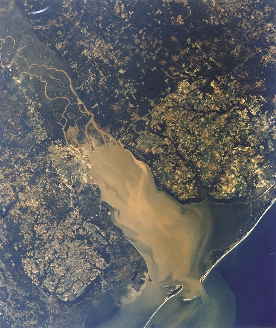
1974 Skylab 4 Landsat Imgery of Mobile Bay showing sediment plumes emanating from river input and D'Olive Creek along the Bay's eastern shore
Once completed, the Lake Forest Lake became a victim of excessive sedimentation, but both D’Olive and Mobile bays have benefited from its existence. The Lake is very efficient at keeping coarse-grained sediments out of D’Olive Bay (Isphording, 1981) and some of the suspended silt and fine-grained sediment out of the bays, as well (Cook, 2013). Excessive sedimentation and shoaling in the Lake was an issue driving the convening of the D’Olive Working Group in 2006, leading to a 2007 Geological Survey of Alabama (GSA) sediment loading analyses, and the development of the D’Olive Creek, Tiawasee Creek, and Joe’s Branch Watershed Management Plan (D'Olive WMP) in 2010. Pursuing a watershed planning framework to guide project identification and implementation, the MBNEP adopted sediment analyses as logical precursors to watershed management planning.
To assess the impacts of land-use change, Cook (2007) measured bed loads (larger particles moving on or periodically near the stream bed) and suspended loads (relatively small particles suspended in the water column) to determine sedimentation rates in the three principal streams and their tributaries in the D’Olive Watershed. He found high sedimentation rates, with higher loads Statewide only in the more mature urban watersheds in the City of Tuscaloosa. As a result of this analysis, the Alabama Department of Environmental Management (ADEM) added the three principal streams and two unnamed tributaries to the 2008 Alabama 303(d) List of Impaired (polluted) Water Bodies for siltation (habitat alteration) from land development.
The D’Olive WMP determined that sedimentation problems in this watershed resulted from chronic stream bank erosion, stimulated by four factors which that Mr. Cook referred to as “the perfect storm” of stormwater runoff and erosion: 1) extreme rolling topography, 2) over five feet of hard rainfall annually, 3) highly erodible soils, and 4) at the time of publication, 47% of the watershed was characterized as urban, with significant impervious cover. It determined that D’Olive Creek supplies approximately 84% of the total sediment load delivered to Lake Forest Lake. In 2010, of almost 23 miles of streams flow through the Watershed, two miles were substantially degraded by stormwater runoff and sediment accumulation, four miles were currently being degraded, and six miles had potential for future degradation. Wetlands were also degraded by sedimentation, providing opportunities for infestation by invasive exotic species.
With almost $12 million in funding primarily through the National Fish and Wildlife Foundation Gulf Environmental Benefit Fund and guided by the D’Olive WMP, the MBNEP undertook a comprehensive stream restoration program in the Watershed. Their primary goal was to “stop the bleeding” and stem sources of erosion degrading downstream fisheries habitat in D’Olive and Mobile Bays. The program involved the restoration (as of July 2020) of 11,528 linear feet of degraded streams and 71 acres of riparian buffer and floodplains, resulting in erosion reduction of 5,272 tons of sediment per year. As a result of this restoration program, sediment loads in Joe’s Branch, which delivered the highest normalized (by drainage area) sediment loads ever monitored by the GSA, were reduced by over 90%. In April 2020, As a result of these reductions ADEM officially removed/delisted Joe’s Branch from the 2020 Alabama 303(d) List.
Sediment Budget for the Mobile Bay Estuary. In 2013, the MBNEP partnered with the U. S. Army Corps of Engineers and sediment experts to develop a Sediment Budget for Mobile Bay and the Delta to establish baseline sediment conditions and determine the relationship between fringe wetlands and sediment dynamics to identify positive and/or negative impacts associated with dredged material management practices, including circulation impacts from dredged material mounding, beneficial uses of dredged material, and “within Bay” disposal for erosion reduction. A sediment budget illustrates a balance of the sediment entering and exiting a particular section of the coast or estuarine system.
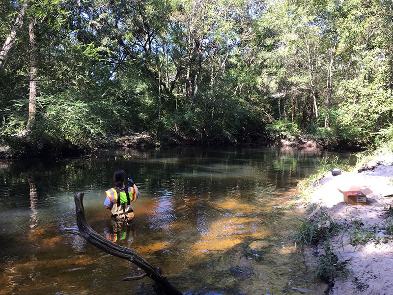
2019 Sediment sampling in Fowl River
Fowl River Watershed. Excess sedimentation is not a problem in all of Alabama’s intertidal watersheds; a scarcity of sediment in the Fowl River Watershed represents the other side of that coin. The Fowl River Watershed Management Plan, published in March 2016, identified degraded marsh spits in the transitional zone between fresh and brackish water as a top priority for restoration. In the 2015 Pre-Restoration Analysis of discharge, sediment transport rates, and water quality in tributaries of Fowl River, Mobile County, Alabama,, Cook et.al. revealed that Fowl River sediment loads are among the smallest of any monitored watershed in the State.
In the comprehensive 2019 Fowl River Marsh Spit Health Study undertaken by principal investigators from the MBNEP’s Science Advisory Committee, Cook concluded that estimated sediment loads, significantly below the geologic erosion rate (estimated erosion rates in the absence of human impact), confirm that the Watershed is sediment-starved. Evaluation of bottom sediment samples also confirms that coarse-grained sediment is limited, with deposition only in isolated areas of the upper and mid-river. Therefore, adequate sediment for accretion (sediment deposition) to sustain the marshes under the impacts of sea level rise is unavailable. Additionally, water column stratification caused by tidal movement of brackish water upstream along the bottom of the river has effectively trapped much of the suspended sediment at or near the bottom, preventing overbank deposition of sediment and limiting material available for marsh accretion.
References cited.
Isphording, W. C. (1981). Sedimentological Study of D'Olive Bay and its Drainage Basin, Baldwin County, Alabama. University of South Alabama.


