Three Mile Creek - Invasive Species Control Plan
THREE MILE CREEK WATERSHED
Invasive Species Control Plan
Download Report (PDF, 8.9MB)
Three Mile Creek is a tributary of the Mobile River and drains approximately 30.1 sq. mi. through a mix of residential, commercial, industrial, and undeveloped sections of Mobile and Prichard, Alabama. The area includes habitat-rich wooded wetlands supporting a broad diversity of freshwater, estuarine, and marine species, along with highly urbanized areas.
Competition among species is a natural part of any ecosystem, but introduction of exotic species can disrupt intricate balances and relationships evolved over thousands of years among native species and their communities. These invasions often cause a loss of biological diversity within both the plant and animal communities (Vitousek 1990). To prevent this loss of biological diversity and improve water quality, Mobile Bay National Estuary Program requested development of an Invasive Species Control Plan for the Watershed.
The purpose of this Invasive Species Control Plan is to remove or control invasive plant and animal species within the Three Mile Creek Watershed, based upon available and survey data.
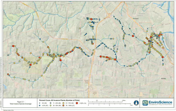
In order to provide a quantitative evaluation of invasive species within the Three Mile Creek Watershed, the Team used a plot-based sampling design to document invasive and native species and their locations within major waterway corridors. Spring and fall field surveys were completed to coincide with peak visibility of target species and to maximize positive identification through flowers or other diagnostic features.
The surveyed waterways included the entire run of the main channel of Three Mile Creek, extending from its headwaters downstream to approximately 1 km from the confluence with the Mobile River. A total of 368 sites were sample and equaled an area of 304,200 m2 (75.2 acres), or approximately 9.3% of the riparian area of the Three Mile Creek Watershed (810 acres).
From the survey, a total of 43 invasive plant species and two invasive animal species were quantified within the Three Mile Creek Watershed during the two sampling events. The five invasive plant species most frequently observed in the plots on a presence/absence basis were Chinese tallow tree, alligatorweed, Chinese privet, cogongrass, and Japanese climbing fern. The most prevalent invasive animal observed was the island apple snail.
From this data, watershed-wide and species-specific control applications were developed to control invasive species within the Three Mile Creek Watershed. The plan is broken into eight key areas for implementation and should be followed as listed below.
- Obtain access to large parcels within the Watershed for invasive control efforts
- Strategy 1. Manage and protect existing intact native communities
- Strategy 2. Target high or moderate density non-native invasive communities
- Strategy 3. Continue and expand island apple snail removals
- Use budgeting tool and species location maps to prioritize site selection
- Reestablish native plant communities in riparian areas
- Continue monitoring the Watershed to detect new invasive species while they are present in low numbers
- Conduct community outreach regarding invasive species detection and control
Download Full Report (PDF, 8.9MB)


