Climate Change
Along the northern Gulf Coast, we face increased risks from climate change-related stressors, including:
- Warmer summers, winters, and waters;
- Increasing incidences and durations of drought,
- Increasing frequency and intensity of tropical weather events, and
- Rising sea level.
The MBNEP and its Management Conference are acutely aware of the vulnerability of the human community and coastal ecosystems to these impacts.
Alabama Coastal Comprehensive Plan. The U. S. Army Corps of Engineers (USACE) has partnered with the Alabama Department of Conservation and Natural Resources, the Mississippi-Alabama Sea Grant Consortium (MASGC), and the MBNEP to develop a constituent-informed, science-based Alabama Coastal Comprehensive Plan (ACCP) to identify ways to reduce vulnerability and increase coastal resilience. Developing the ACCP included 19 visioning exercises with different community and public stakeholder sectors across Alabama’s coastal counties. Input from participants, along with available data that includes 295 Federal Emergency Management Agency storm stimulations, contributed to this coast-wide vulnerability and adaptability assessment with mapping tools to identify risks related to sea-level rise. ACCP/Interactive Map
Watershed Vulnerability Assessments. With our CCMP prescribing watershed planning to ensure stakeholder participation and cooperation between different drainage area jurisdictions, the MBNEP requires planning contractors to assess climate change vulnerability in each watershed management plan (WMP) published. Development of individual models is not expected, but planning teams can rely on currently available information, like the USACE’s coastal vulnerability assessment included in their ACCP. Most WMPs include Sea Level Affecting Marsh Models (SLAMM), which simulates processes involved in wetland conversions and shoreline modifications, and Sea, Lake, and Overland Surges from Hurricanes (SLOSH) models, which estimate storm surge heights resulting from historical, hypothetical, or predicted hurricanes. The Coastal Resilience Index, developed by the MASGC, is recommended as a tool for conducting local vulnerability assessments as a component of watershed planning. Completed WMPs are located in the MBNEP Publication Library.
Watershed Management Plan Implementation. With WMPs completed, under development, or slated for each of Alabama’s 48 tidally influenced 12-digit Hydrologic Unit Code watersheds, many recommended measures will be related to decreasing vulnerability or increasing resilience to climate change impacts.
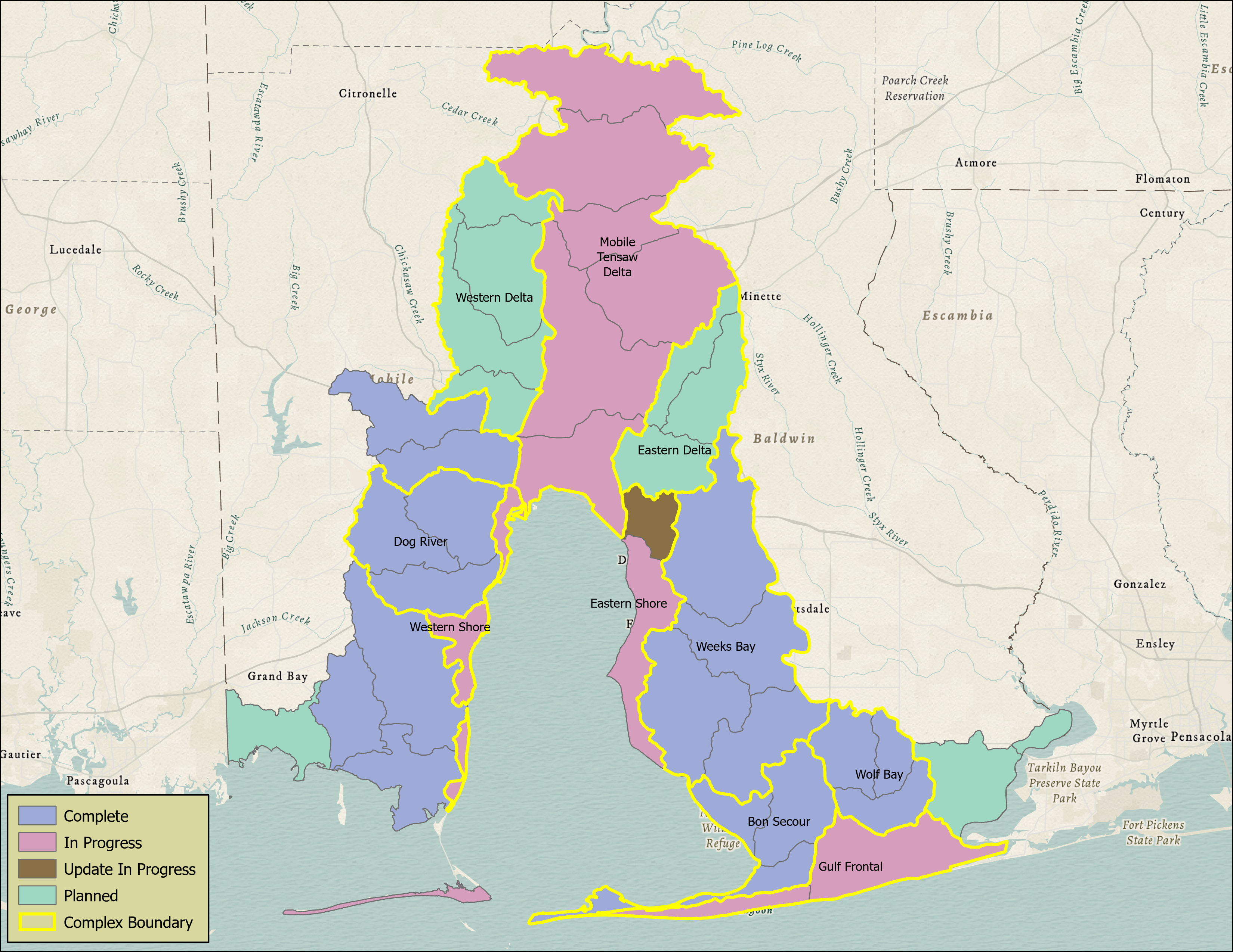
Watershed management plan's complete (blue), in progress (pink), update in progress (brown), planned (green), complex boundary (yellow outline) March 2021
Three Mile Creek Watershed. Several activities recommended in the Three Mile Creek WMP, the first to include climate change vulnerability assessments, have been implemented to address climate vulnerabilities in low-lying, traditionally underserved minority communities:
- Auburn University scientists assessed hydrology in the Toulmins Spring Branch (TSB) Subwatershed, groundtruthed subwatershed boundaries, located and characterized stormwater outfalls, characterized flow and depth to establish stormwater curves, calibrated a stormwater management model, and conducted water quality sampling.
- A Community Solutions Fellow from Bangladesh collaborated with the Auburn team to determine areas of low elevation, seek input from residents to identify areas of flooding and neglect, and described conditions underlying identified problem areas.
- The MBNEP funded the Prichard Drainage Study: Toulmins Spring Branch and Gum Tree Branch for the Mobile County Commission. It included recommendations for low-impact development measures to improve stormwater management and reduce flooding and increased maintenance by the County, municipalities, and others.
- In 2015, MBNEP engaged TSB residents in community planning to adapt to climate change impacts and build capacity for improving community resilience. Three community meetings and an Ideas Festival were held to educate residents about the environment, causes of flooding and water pollution, and how hazards will increase due to effects of climate change.
- Based upon Prichard Drainage Study recommendations, MBNEP initiated the Prichard Rain Barrel Program with partners from the Plant Barry Environmental Stewardship Team and Soterra/Greif, Inc. This TSB community program concentrates on installing free, two-barrel rainwater harvesting systems to reduce runoff, educate residents about sources and mitigation of stormwater runoff, and provide a free source of non-potable water (to residents who pay disproportionately high water bills) for gardens and household uses.
Fowl River Marsh Spits. With restoration of four erosion-impacted salt marsh-covered spits a priority recommendation of the Fowl River WMP, the MBNEP secured funding to initiate a Marsh Health Study.. Conducted by principal investigators from MBNEP’s Science Advisory Committee, the study examined why salt marshes in the River’s transitional zone between fresh and brackish water appear to be degrading from interior to exterior portions of the marsh. This comprehensive study included assessments of marsh condition, investigations of stressors (including sea level rise) potentially underlying observed degradation, and a hydrologic model to ensure restoration efforts keep pace with relative sea level rise. With other factors, like increased salinity, not rejected, it appears a combination of rising water levels and wakes from recreational boat traffic are the “smoking gun” underlying the degradation. Engineering and design of Fowl River Watershed Restoration: Coastal Spits and Wetlands Project-Phase 1 are currently in progress.
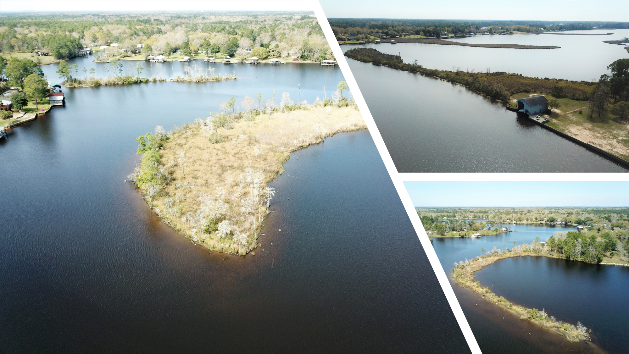
Fowl River Spits: Closing Hole (left), Tapia (top), Lightcap (bottom)
Shoreline Restoration Efforts. With management plans for coastal watersheds in development and National Fish and Wildlife Foundation Gulf Environmental Benefit Funds secured, shoreline stabilization projects are increasingly being implemented. The Nature Conservancy’s Lightning Point Acquisition and Restoration Project, recommended in the Bayou La Batre WMP, and Mobile County’s Salt Aire Shoreline Restoration project on the Bay’s western shore are currently under construction. Engineering and design are underway for significant shoreline restoration/stabilization projects in Western Shore Watersheds, including Deer River Shoreline Restoration near the Theodore Industrial Canal and the Dauphin Island Causeway Shoreline Restoration project between the Heron Bay Cutoff and the Dauphin Island Bridge. With management plans in development or slated for the low-lying, Gulf-fronting, and extremely storm-vulnerable watersheds, including Baldwin County’s Gulf Frontal and Mobile County’s Dauphin Island watersheds, respectively, climate change impacts will be key to future project recommendations.


