The Landscape
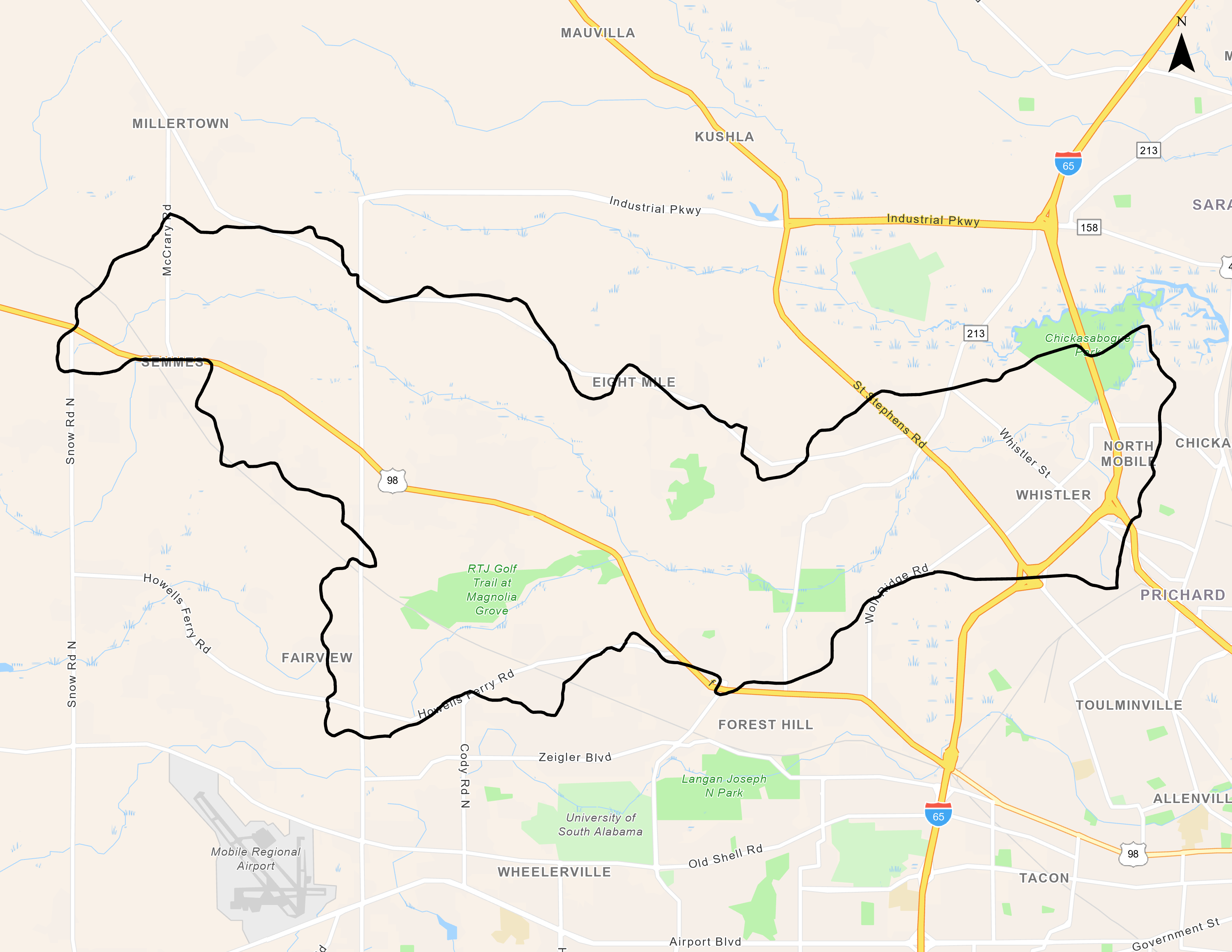
Watershed Size and Location
Eightmile Creek covers over 23,600 acres in Mobile County within the Cities of Mobile, Prichard, Semmes, and Chickasaw and unincorporated areas of Mobile County. Although the lower portion of the watershed, primarily within the cities of Prichard and Chickasaw, is highly urbanized (14% total land use), the watershed is dominated by Forest at 55% with Agriculture and Pasture accounting for 7% and 18% respectively.
Main Tributaries and Tidal Influence
The Eightmile Creek (HUC 031602040403) is fed by two named tributaries, Red Creek and Gum Tree Branch. Tidal influence is typically limited to the lower reaches of Eightmile Creek, near its confluence with Chickasaw Creek.
Water Use Classification and Impairments
Eightmile Creek and its tributaries are classified as Fish & Wildlife usage with Eightmile Creek additionally classified for Public Water Supply because of the presence of the water intake of the City of Prichard near the confluence of Gum Tree Branch. Eightmile Creek and Gum Tree Branch have been included in the State of Alabama’s 303(d) list of impaired waters since 1998. Both are categorized as impaired by pathogen pollution (fecal coliform) due to urban runoff and sanitary sewer collection system failure. TMDLs for pathogens have been developed for both Eightmile Creek and Gum Tree Branch.
Human Uses
The 2006 City of Prichard Comprehensive Plan states that the historic settlement of Africatown includes portions of Prichard and Mobile bordering Telegraph Road (U.S. 43). While settlers arrived in the 1830’s, its most notable settlers and namesakes arrived in 1860 when a slave trade ship named the Clotilde landed on the banks of the Mobile Bay about three miles north of downtown Mobile. The land marked the last recorded attempt to import Africans into the United States for the purpose of slavery. These people would later form the nucleus of Africatown. After the Civil War, the original group of intended slaves and others who joined them formed their own, largely self-governing community, all the while maintaining a strong sense of African cultural heritage. This sense of heritage and sense of community remains today. A large parcel of undeveloped, city-owned land along Chicasabogue Creek between Shelton Beach Road and Crystal Springs Road in the Eightmile area has been designated by the State of Alabama for future development as a state park celebrating the history of the Africatown community. A living-history African village concept has been proposed for the park. Currently, access to Eightmile Creek is very limited, although some recreational and subsistence fishing does occur, there is little in the way of public access. The City of Prichard does have a small passive park, Jackson-Reading Park, along the banks of an unnamed tributary to Eightmile Creek.
Ecological Importance
The primary natural resources in the Watershed include both parcels of undeveloped woodland and marshland, especially in the northern portion, and creek and estuary environments, including Eightmile Creek, Chickasabogue Creek, and their tributaries and branches. Eightmile Creek’s riparian corridor includes a wide floodway and relatively steep banks. The U.S. Fish and Wildlife Service has noted that the endangered Alabama red-bellied turtle (Pseudemys alabamensis) may be found in Eightmile Creek and Gum Tree Branch.


