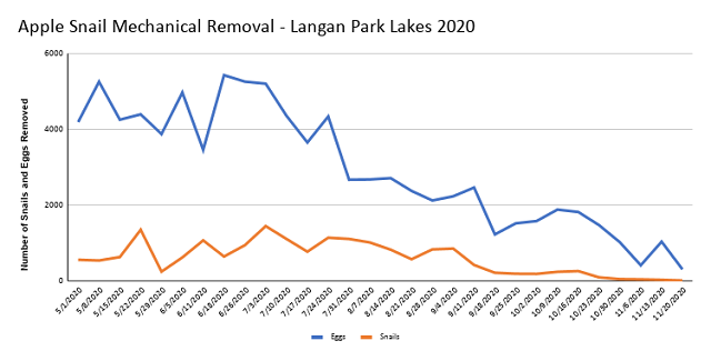
Skip to content
  • Calendar|
  • News|
  • Contact Us
Mobile BayNational Estuary Program A Division of The Dauphin Island Sea Lab
  • Who We Are
    • Our History
    • Management Conference
    • Our Partners
    • Our Staff
    • Contact Us
  • What We Do
    • Bays and Bayous Symposium
    • Alabama Coastal Comprehensive Plan
    • CCMP: Comprehensive Conservation and Management Plan
    • Workplans
    • Coastal Alabama Fisheries Fund
    • Educational Resources
    • Clean Water Future
    • Masterpiece Survey
  • What We Value
    • Access
    • Beaches, Dunes and Shorelines
    • Fish and Wildlife
    • Heritage and Culture
    • Resilience
    • Water Quality
  • Where We Work
    • The Coverage Area
    • The Coast
    • The Estuary
    • The Watershed
  • The Issues
    • Apple Snails
    • Climate Change
    • Coal Ash
    • Conversion of Natural Habitats
    • Deepwater Horizon Oil Spill
    • Invasive Species
    • Legacy Contaminants
    • Nutrients
    • Pathogens
    • Seagrass
    • Sediments
    • Storm Runoff
    • Submerged Aquatic Vegetation - Alabama’s Seagrass Beds
  • Watersheds
    • Bayou La Batre
    • Bon Secour
    • Dauphin Island
    • Dog River
    • D'Olive Creek
    • Eastern Shore
    • Eight Mile Creek
    • Fowl River
    • Gulf Frontal-Perdido
    • Mobile Tensaw Delta
    • Mon Louis Island
    • Three Mile Creek
    • Weeks Bay
    • West Fowl River
    • Western Delta
    • Western Perdido Bay
    • Western Shore
    • Wolf Bay
  • What We Monitor
    • ACCP: Alabama Coastal Comprehensive Plan
    • AL Coastal Marine Planning Tool
    • Alabama Water Watch
    • Fish Consumption Advisories
    • Habitat Mapping for Coastal Alabama
    • MyMobileBay.com
    • Shellfish Aquaculture Siting Tool
  • Library
    • Publications
    • Videos
  • Who We Are
  • What We Do
  • What We Value
  • Where We Work
  • The Issues
  • Watersheds
    • ACCP: Alabama Coastal Comprehensive Plan
    • AL Coastal Marine Planning Tool
    • Alabama Water Watch
    • Fish Consumption Advisories
    • Habitat Mapping for Coastal Alabama
    • MyMobileBay.com
    • Shellfish Aquaculture Siting Tool
  • Library

© 2023 Mobile Bay National Estuary Program. All rights reserved
Website by Blue Fish

Watersheds

  • Home
  • Watersheds
  • Three Mile Creek
  • Apple Snail Control

WATERSHEDS

  • The Landscape
  • The Community
  • The Planning
  • The Restoration
  • Apple Snail Control
  • Back to Overview

Apple Snail Control

Apple Snail Control Plan FAQs

Request for Proposals to Undertake Control Measures to Eradicate the Invasive Island Apple Snail from the Municipal/Langan Park Lakes

Soils Exploration and Geotechnical Engineering Studies City of Mobile Langan Park Lakes

Apple Snail Mechanical Removal Langan Park Lakes 2020

Effects of and Control Methods for the Invasive Apple Snail in Southwest Alabama, 2008

Control of Invasive Exotic Island Apple Snail in Southwest Alabama, 2009

Thoughts on Apple Snail Control Work and Three Mile Creek Invasives Plan

Pre-Proposal Meeting Information

footer MBNEP logo

MOBLE BAY NATIONAL ESTUARY PROGRAM ASSOCIATED SITES:

  • DIS Llogo white footer75
  • My Mobile Bay white footer75
  • CWF Logo white footer75
  • Who We Are
  • What We Do
  • What We Value
  • Where We Work
  • The Issues
  • Watersheds
  • Library
  • NEWS
  • CONTACT

© 2023 Mobile Bay National Estuary Program. All rights reserved Blue Fish

  • Who We Are
  • What We Do
  • Watersheds
  • Library
  • Menu